Hidden Worlds: 7 Recently Mapped US Cave Systems for 2026
Advertisements
Seven recently mapped cave systems across the US are revealing unprecedented insights into unique subterranean ecosystems, offering vital scientific discoveries and expanding our understanding of Earth’s hidden worlds by 2026.
Advertisements
Beneath the familiar landscapes of the United States lie vast, intricate networks waiting to be explored. These subterranean realms, often overlooked, harbor secrets that challenge our understanding of life and geology. In recent years, remarkable advancements in mapping technology and sustained exploration efforts have brought to light incredible new discoveries. This article delves into Hidden Worlds: 7 Recently Mapped Cave Systems in the US Revealing Unique Ecosystems for 2026, offering a glimpse into the extraordinary biodiversity and geological wonders found within these newly charted depths.
The Unseen Frontier: Why Cave Mapping Matters
The exploration and mapping of cave systems represent one of the last true frontiers on Earth. These hidden environments are not merely dark, empty spaces; they are complex ecosystems teeming with life adapted to extreme conditions. Understanding these subterranean worlds is crucial for various scientific disciplines, from biology and geology to hydrology and climate science.
Mapping provides the foundational data necessary for all subsequent research. Without accurate maps, scientists cannot effectively study the distribution of species, analyze geological formations, or track water flow through aquifers. The detailed mapping efforts discussed here are paving the way for groundbreaking research and conservation strategies.
Advancements in Cave Mapping Technology
Modern cave mapping has been revolutionized by technological innovations. Gone are the days of relying solely on compasses and measuring tapes. Today, explorers utilize sophisticated tools that provide unprecedented accuracy and detail.
- Lidar Scanning: Laser-based mapping creates highly precise 3D models of cave passages, revealing intricate details and volumes.
- Photogrammetry: Combining multiple photographs to generate 3D models, particularly useful for documenting complex formations or archaeological sites within caves.
- Autonomous Robotics: Drones and remote-controlled vehicles can access areas too dangerous or small for human explorers, expanding the reach of mapping efforts.
- GIS Integration: Geographic Information Systems allow for the comprehensive analysis and visualization of cave data, linking it to surface topography and hydrological networks.
These technologies not only accelerate the mapping process but also enhance safety for explorers and ensure the preservation of delicate cave environments. The precision of these new maps is enabling scientists to make connections and discoveries that were previously impossible, shedding light on the intricate workings of these hidden worlds.
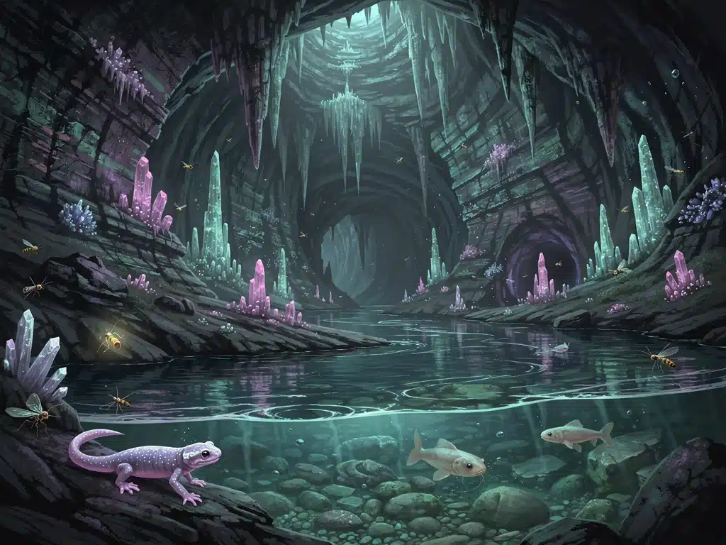
1. The Crystal Caverns of Nevada: A Subterranean Oasis
Deep beneath the arid landscape of Nevada, explorers have recently mapped an astonishing cave system known as the Crystal Caverns. This discovery, anticipated to be fully documented by 2026, reveals a series of vast chambers adorned with colossal gypsum crystals, some stretching several feet in length. The environmental conditions within these caverns are remarkably stable, fostering unique forms of microbial life and several previously unknown invertebrate species.
The significance of the Crystal Caverns lies not only in their aesthetic beauty but also in their potential to offer insights into extremophile biology. The organisms found here thrive in environments with minimal light and unique mineral compositions, providing a living laboratory for studying adaptation and evolution. Researchers are particularly interested in the microbial mats that cover many of the crystal formations, believing they play a critical role in the cavern’s ecosystem.
Geological Formations and Hydrological Links
The geological history of the Crystal Caverns is as captivating as its current state. Formed over millions of years through the dissolution of ancient evaporite deposits, the caverns showcase a spectacular array of speleothems, including delicate ‘cave flowers’ and massive pillars. Hydrological studies indicate a complex connection to ancient groundwater systems, suggesting the caverns may serve as a vital reservoir or conduit for water beneath the desert.
The ongoing mapping efforts are meticulously documenting every passage and chamber, using advanced laser scanning to create a comprehensive 3D model. This model will be instrumental in understanding the cavern’s formation processes and its intricate hydrological network. The hope is that by 2026, a significant portion of this immense system will be fully charted, allowing for more focused biological and geological studies.
2. The Bioluminescent Labyrinth of Kentucky: Glowing Life Below
Kentucky, famous for its extensive cave systems, has yielded another marvel: the Bioluminescent Labyrinth. This newly mapped section of a much larger, previously known system has astounded researchers with its vibrant displays of bioluminescent organisms. Unlike surface ecosystems, where light often comes from the sun, these caves feature a unique array of fungi, bacteria, and insects that produce their own light, creating an otherworldly glow.
The discovery of such a concentrated and diverse bioluminescent community is rare and scientifically invaluable. Scientists are studying the chemical processes behind the light production, hoping to uncover new biochemical pathways that could have applications in various fields, from medicine to sustainable lighting. The ecological relationships within this glowing labyrinth are also a major focus, as the light source plays an integral role in the food web and communication among species.
Adaptations to Perpetual Darkness
Life in perpetual darkness leads to extraordinary adaptations. The creatures of the Bioluminescent Labyrinth exhibit a range of unique traits:
- Loss of Pigmentation: Many species are albino, as color offers no advantage in the absence of light.
- Enhanced Sensory Organs: Developed senses of touch, smell, and hearing compensate for the lack of sight.
- Slowed Metabolism: Limited food resources often lead to lower metabolic rates and longer lifespans.
- Chemosynthetic Dependence: Some ecosystems rely on chemical energy rather than photosynthesis, with bioluminescence potentially playing a role in attracting prey or mates.
The mapping of this labyrinth is not just about charting passages; it’s about understanding the spatial distribution of these glowing organisms and their interaction with the cave environment. By 2026, researchers aim to have a detailed understanding of the labyrinth’s layout and the ecological hotspots within it, facilitating targeted research and conservation efforts for these fragile, glowing ecosystems.
3. The Subterranean Rivers of Oregon: Ancient Waterways Revealed
In the Pacific Northwest, beneath the volcanic terrain of Oregon, a vast network of subterranean rivers has been extensively mapped. These newly charted waterways, part of an intricate karst system, play a critical role in the region’s hydrology, feeding springs and contributing to surface rivers. The mapping project, nearing completion by 2026, has uncovered not only the pathways of these underground rivers but also unique aquatic ecosystems within them.
The water in these rivers is remarkably pure, filtered by miles of rock. This purity, combined with the stable temperatures, creates an ideal habitat for specialized aquatic life, including blind cave fish, unique crustaceans, and microbial communities. Scientists are studying these ecosystems to understand their resilience and their vulnerability to changes in surface water quality and quantity.
Hydrological Significance and Conservation
The detailed maps of Oregon’s subterranean rivers are invaluable for water resource management. They reveal the intricate connections between surface and underground water, helping authorities to make informed decisions about land use and pollution prevention. Protecting these hidden waterways is essential for maintaining the health of the entire regional ecosystem.
- Aquifer Recharge: Understanding how these rivers recharge aquifers is vital for sustainable water supply.
- Pollution Pathways: Mapping helps identify potential routes for surface pollutants to enter and contaminate underground water sources.
- Biodiversity Hotspots: These rivers are home to endemic species, making their conservation a high priority.
The work in Oregon highlights the critical intersection of geological mapping, hydrological science, and ecological conservation. The comprehensive maps expected by 2026 will serve as a cornerstone for future research and environmental protection initiatives in the region.
4. The Ice Caves of Alaska: Frozen Worlds Beneath the Tundra
Alaska’s vast and unforgiving landscape holds secrets beneath its frozen surface. Recently, extensive mapping efforts have unveiled several interconnected ice caves, revealing dynamic frozen worlds that defy conventional understanding of cave environments. These caves, formed within glaciers and permafrost, are constantly shifting, presenting unique challenges for exploration and scientific study.
The ecosystems within these ice caves are unlike any other. Specialized microbial life thrives in the frigid temperatures, often embedded within the ice itself. Scientists are studying these extremophiles for their potential biotechnological applications and for insights into life in extraterrestrial icy environments. The caves also provide a pristine record of past climates, with ancient ice layers containing trapped air bubbles and pollen that tell stories of millennia gone by.
Glacial Dynamics and Climate Change Indicators
The mapping of Alaska’s ice caves is not just about discovering new spaces; it’s about understanding glacial dynamics and the impact of climate change. The structural integrity and evolution of these caves are directly linked to the health of the glaciers and permafrost that contain them. As global temperatures rise, these frozen worlds are changing rapidly.
The detailed maps offer a baseline for monitoring these changes. By 2026, researchers hope to have a clearer picture of how these ice caves are responding to a warming climate, providing crucial data for climate models and conservation strategies. The unique organisms found within also offer a glimpse into the potential for life in extreme cold, expanding our understanding of biological limits.
5. The Lava Tubes of Hawaii: Volcanic Subterranean Habitats
Beneath the lush volcanic landscapes of Hawaii, a network of extensive lava tubes has been meticulously mapped, revealing fascinating subterranean habitats. These tubes, formed by ancient lava flows, are natural tunnels that provide shelter from the harsh tropical sun and rain, creating stable microclimates for unique ecosystems. The ongoing mapping project, set for significant completion by 2026, highlights the incredible biodiversity adapted to these dark, nutrient-poor environments.
The organisms found in Hawaiian lava tubes are often endemic, having evolved in isolation within these specific underground channels. Blind spiders, cave-dwelling crickets, and unique microbial communities thrive here, relying on limited food sources that filter down from the surface or on chemosynthetic processes. These ecosystems are fragile and susceptible to disturbance, making detailed mapping and conservation efforts paramount.
Geological Formation and Ecological Resilience
Lava tubes are geological marvels, offering direct evidence of Hawaii’s volcanic history. Their formation processes, characterized by surface lava flows cooling and hardening while molten lava continues to flow beneath, create vast, intricate networks. Studying these tubes provides insights into volcanism and geological evolution.
- Unique Microclimates: Stable temperatures and high humidity provide refuge for specialized species.
- Endemic Species: Many organisms are found nowhere else on Earth, making their preservation crucial.
- Nutrient Cycling: Understanding how nutrients are transported and utilized in these resource-limited environments.
By 2026, the comprehensive mapping of these lava tube systems will not only enhance our geological understanding but also provide critical data for protecting these fragile, unique ecosystems from human impact and invasive species. The resilience of life in such extreme conditions offers profound lessons for biology.
6. The Karst Caves of Florida: Underwater Wonders
Florida’s geology is dominated by karst, leading to a sprawling network of underwater caves and springs. Recent mapping expeditions have focused on extending known systems and discovering new passages within these submerged environments. These underwater caves, often filled with crystal-clear fresh water, are critical components of Florida’s hydrological system and host incredibly diverse aquatic life.
The mapping of these underwater caves is exceptionally challenging, requiring specialized diving equipment and techniques. However, the rewards are immense. Explorers have documented vast chambers, intricate passages, and unique speleothems formed underwater. The ecosystems within these caves include blind cave fish, endemic invertebrates, and specialized microbial communities adapted to life in constant darkness and stable water conditions.
Conservation of Florida’s Aquatic Caves
Florida’s underwater caves are under increasing threat from surface pollution and over-extraction of groundwater. The detailed maps being developed are essential tools for conservation, helping to identify sensitive areas, track pollution pathways, and understand the flow of water through the state’s aquifers.
The unique biodiversity of these caves also makes them a high priority for protection. Many species are highly sensitive to changes in water quality and habitat. By 2026, the improved understanding of these systems will support more effective management strategies to safeguard these vital natural resources and their hidden inhabitants.
7. The Gypsum Caves of Texas: A Desert’s Hidden Depths
In West Texas, beneath the Chihuahuan Desert, a series of extensive gypsum caves has been undergoing intensive mapping. Unlike limestone caves, gypsum caves are formed in softer rock, often resulting in intricate, delicate formations and unique mineralogical features. These newly mapped systems are revealing vast, interconnected passages that stretch for miles, offering a glimpse into a rarely studied subterranean environment.
The ecosystems within Texas’s gypsum caves are adapted to the unique chemistry of their surroundings. Specialized bacteria and fungi thrive on the gypsum, forming the base of a food web that supports a variety of troglobites—animals that live exclusively in caves. These include blind salamanders, unique insects, and other invertebrates, many of which are new to science. The stable temperature and high humidity provide a stark contrast to the harsh desert above.
Mineralogical Wonders and Biological Adaptations
The gypsum caves are a treasure trove for mineralogists, featuring delicate crystal formations, such as selenite needles and gypsum flowers, that are rarely seen in other cave types. These formations are fragile and require careful documentation and protection during exploration. The biological adaptations to this unique environment are equally compelling.
- Unique Mineral Formations: Gypsum crystals create stunning and fragile geological displays.
- Specialized Troglobites: Organisms adapted to gypsum-rich environments, often with unique physiological traits.
- Microbial Diversity: Microorganisms playing key roles in nutrient cycling within the cave ecosystem.
By 2026, the comprehensive mapping of these gypsum caves is expected to provide scientists with an unparalleled understanding of their geological evolution and the remarkable biological communities they host. This knowledge is crucial for their long-term preservation and for advancing our understanding of life in extreme, mineral-rich environments.
| Cave System | Key Discovery/Ecosystem |
|---|---|
| Crystal Caverns, Nevada | Vast chambers with colossal gypsum crystals and unique microbial life. |
| Bioluminescent Labyrinth, Kentucky | Concentrated and diverse bioluminescent organisms creating an otherworldly glow. |
| Subterranean Rivers, Oregon | Intricate network of pure underground waterways with specialized aquatic life. |
| Ice Caves, Alaska | Dynamic frozen worlds with extremophile microbes and climate records. |
Frequently Asked Questions About US Cave Discoveries
These recently mapped cave systems are significant because they reveal unique, previously unknown ecosystems, extremophile life forms, and crucial hydrological or geological features. They expand our understanding of subterranean biodiversity, climate history, and water resources, offering invaluable data for scientific research and conservation efforts.
Scientists primarily use advanced technologies such as Lidar scanning, photogrammetry, and autonomous robotics to map complex underground environments. These tools create highly accurate 3D models and allow access to areas too dangerous or small for human explorers, greatly enhancing the detail and efficiency of mapping projects.
Unique life forms found in these caves include blind cave fish, specialized insects and crustaceans, bioluminescent organisms (fungi, bacteria), and various extremophile microbial communities. These organisms have evolved specific adaptations to thrive in perpetual darkness, stable temperatures, and often nutrient-poor or chemically distinct environments.
Generally, most newly mapped cave systems, especially those with fragile ecosystems or challenging access, are not immediately accessible to the public. Access is often restricted to scientific researchers and highly experienced cave explorers to protect the delicate environments and ensure safety. Public access might be considered for select, more robust sections in the future.
Discoveries in ice caves provide pristine climate records through ancient ice layers, offering insights into past atmospheric conditions. Hydrological studies in karst systems help understand water flow, which is vulnerable to climate shifts. Overall, these findings offer crucial baseline data and indicators for monitoring environmental changes and validating climate models.
Conclusion: Peering into Earth’s Unseen Depths
The ongoing exploration and detailed mapping of these seven remarkable cave systems across the United States underscore the vastness of Earth’s unexplored realms. From the crystalline wonders of Nevada to the bioluminescent glow of Kentucky, and the icy frontiers of Alaska, each discovery offers a unique window into specialized ecosystems and geological processes. These hidden worlds, anticipated to be more fully understood by 2026, are not just curiosities; they are vital natural laboratories providing unparalleled insights into evolution, hydrology, and our planet’s history. As technology advances, so too does our ability to respectfully uncover and protect these subterranean treasures, ensuring their secrets continue to enrich scientific knowledge and inspire awe for generations to come. The commitment to meticulous mapping and interdisciplinary research is paramount to safeguarding these fragile environments and the extraordinary life they harbor, reminding us that even in a well-explored nation like the US, profound mysteries still lie just beneath the surface.